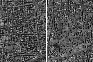
 Wanna know how hard Isreal is hitting Lebanon in their conflict with Hezbollah? You can see the impact from space.
GeoEye has a pair of stunning "before & after" satellite images showing the damage on a chunk of Beirut. The image on the left was taken July 12. The image on the right on July 31.
Their site features a movable/searchable mosaic of Beirut from the airport to surrounding areas taken on July 31. (GeoEye via Yahoo! News)
1 comment:
Thanks for the post.
I clicked your link and found the photo of Beruit after the bombings. What I found stunning was that basically just the one area that you posted pictures of was the only area bombed. There are a few exceptions such as the airport and a couple of scattered places.
I found you by hitting "next blog" in the right hand corner for at least 10 minutes. It's unbelievable how many blogs there are and so few have anything to do with politics.
I see your blog gets about as much traffic as mine....
If you would like to visit my blog (I am desperate for attention!) :-) come on over for a visit I'm having an "end times" blog party (yes, all by myself with one exception, my son)....
Anyways, here's the link:
http://majorinsanity.blogspot.com/
Post a Comment